On our way to Sully Creek, we stopped at Belle Fourche, SD, to check out the Center of the Nation Monument. It was a nice place to stretch our legs. The actual center of the nation is 20 miles away from the monument. You can get directions from the visitor center if you like.
When we arrived at Sully Creek, they were starting an electrical install to the sites. The electrician had parked on our reserved site. So, we went and talked to the ranger. He allowed us to park in the camping area reserved for those camping with horses. Win! Though we were dry camping (no hookups), our site was a big loop with a horse corral in the middle. The site was big enough that we noted that they were planning for three electrical hookups in the loop. The site was much more private, shady, and as an extra bonus, the view was better too.
 |
| Our "horses" were pink and plastic |
 |
| Evening view |
Back to the national park, we drove the South Unit, taking in a few short hikes to overlooks and a coal vein. The loop drive had experienced a landslide and instead of being a loop, it was a 24 mile drive in and back out. We pretty much took the entire day to view the area. While we saw buffalo, it was the herds of wild horses that stood out.
 |
| Wind Canyon |
We had one day left in the area. We had debated about driving to the North Unit, since it was an hour drive away. The ranger noted that it was the prettier unit, more rugged, and the most photographed spot in North Dakota was located in the North Unit, Rainbow Bend. Well, that settled it.
So, the next day, we headed north to the North Unit. The ranger was right. We both agreed that the North Unit was more scenic. The first part of the park is driving through the badlands area. Then you arrive at the top of the buttes where miles and miles of grasslands greet you with herds of buffalo dotting the landscape.
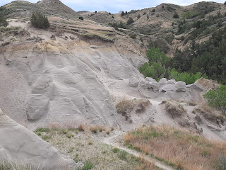
We hiked the 4.3 mile Caprock Coulee loop trail. It was considered a moderate trail, taking you through the coulee before going up through the ravines to the top for some amazing views and back down. It took us right at three hours with a couple of stops, including the most photographed overlook.
We both agreed that the trail was about the max we would care to do in a day. We were sure glad we had hiking poles. There were a couple of areas that had lots of loose rock and other areas that honestly, made us wonder how safe it was. That bentonite rock has some serious erosion going on and the cracked surface made us think it was ready to crumble at any given moment. All that said, it was worth the effort.
Caprock Coulee Trail View - North Unit
Rock formations - North Unit


No comments:
Post a Comment